

The National Weather Service’s Weather Prediction Center (WPC) has forecast multiple weather hazards across the United States from Thursday (December 25), through Saturday (December 27), including excessive rainfall in Southern California, heavy snow in the West and Northeast, and icy conditions in parts of the Mid-Atlantic.
AccuWeather has warned that a strengthening storm off the West Coast will drive another atmospheric river into California through Christmas Day, bringing life-threatening flooding, mudslides, hurricane-force winds and feet of mountain snow.
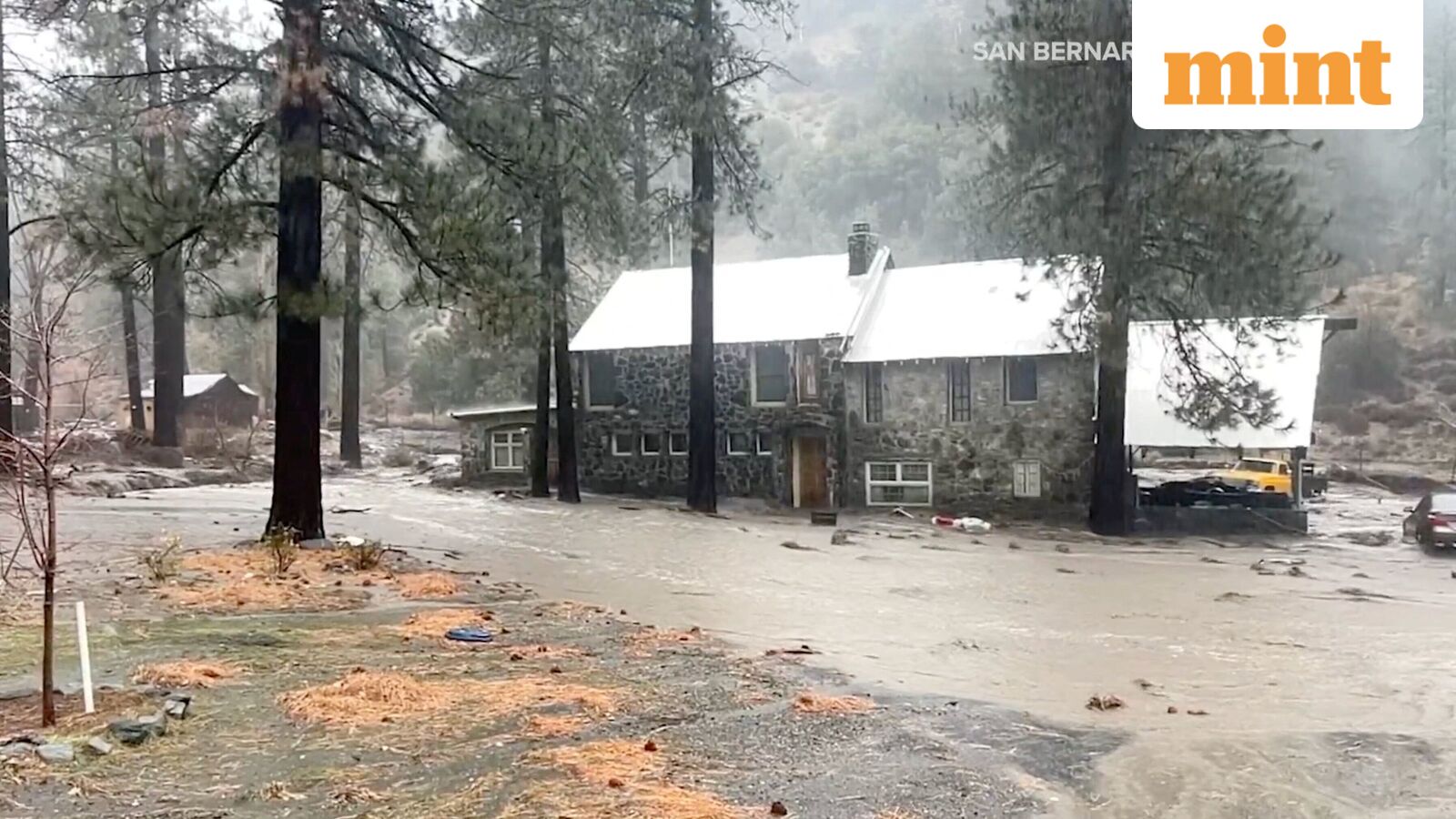
According to AccuWeather, Southern California faces the highest flood risk, with multiple inches of rain falling in just a few hours across urban areas and steep terrain. Coastal Southern California could receive several months’ worth of rain in one to three days.
Los Angeles rainfall to far exceed December average
“The downtown Los Angeles area is projected to receive 4–8 inches of rain, which is two to three times the entire December average,” said AccuWeather Senior Meteorologist Tyler Roys.
According to the WPC, a Moderate Risk (Level 3 of 4) of excessive rainfall is in effect for parts of Southern California from Thursday into early Friday as a strong plume of Pacific moisture moves inland. The agency warned that numerous flash flooding events are possible, along with stream and river flooding.
Debris flow danger near wildfire burn scars
Debris flows may occur in or near recent wildfire burn areas. A Slight Risk of excessive rainfall is in effect for Northern and Central California and parts of Southern Nevada on Thursday, with another Slight Risk extending from Friday into Saturday morning as heavy rain continues.
Historic snowfall expected in Sierra Nevada
Heavy snow is forecast for the Sierra Nevada Mountains through Saturday, with additional significant snowfall expected across the Cascades, Northern Intermountain Region, and the Northern and Central Rockies.
In the mountains, AccuWeather forecast historic snowfall in the Sierra Nevada, with 8–12 feet of snow on many ridges and peaks and isolated totals up to 15 feet, according to AccuWeather Chief Meteorologist Jonathan Porter.
In the eastern US, the WPC said a low-pressure system moving from the Ohio Valley to the Northeast Coast will bring rain to the Ohio Valley and Mid-Atlantic by Christmas, while snow develops across parts of the Northeast.
A second storm system from the Upper Midwest will spread a wintry mix of freezing rain and sleet from Michigan through Pennsylvania and into the Mid-Atlantic, creating hazardous travel conditions.
The WPC noted that up to 0.25 inches of ice accumulation is possible in parts of Pennsylvania, while snow is expected in Michigan’s Upper Peninsula.
The agency added that moderate to heavy snow is likely over New England from Friday into early Saturday, potentially further impacting travel across the region.
Rain and snow will also impact higher elevations of the Great Basin and parts of the Southwest through Saturday.
Newsom proclaims state of emergency
The storm has prompted states of emergency in several counties, including Los Angeles, Orange, Riverside, San Bernardino, San Diego and Shasta, as flooding fears mount. AccuWeather noted that evacuation orders have been issued near burn scar areas in Los Angeles County, forcing some residents to leave their homes through Christmas.
In Shasta County, including Redding, officials are bracing for renewed flooding after a recent deadly event.
“California is acting early and decisively to do all we can to get ahead of dangerous winter storms. The state has pre-positioned resources, activated emergency authorities, and we are working closely with local partners to protect communities and keep Californians safe,” California Governor Gavin Newsom said in a statement.
